Read the latest information on
Foot-and-mouth disease
Zoning is the division of your farm into separate areas based on the level of biosecurity that is needed to minimise the possibility of pests and diseases from coming onto and moving around your property.
Generally, three zones are required to limit access according to the risk status of the area. In order of increasing level of biosecurity measures they are access, separation and farming (or production) zones.
The access zone allows for visitor, staff and delivery access to the property and office. People can come and go, and there is no need to clean their vehicles because they are parked in designated areas near the farm entrance, office or house.
This zone is the roadway for essential vehicles that need to come on-farm. This could include trucks picking up crop products or livestock, food, fertiliser or fuel deliveries. Separation zones might include the tracks and pathways for essential vehicles to access different areas on-farm.
You can also have separation zones between paddocks or areas within a paddock where different crops are grown to help manage the potential spread of pests between growing areas.
This zone is where farm employees, vehicles, machinery, and equipment operate. People, vehicles, machinery or tools should not enter or exit this area without appropriate measures being used.

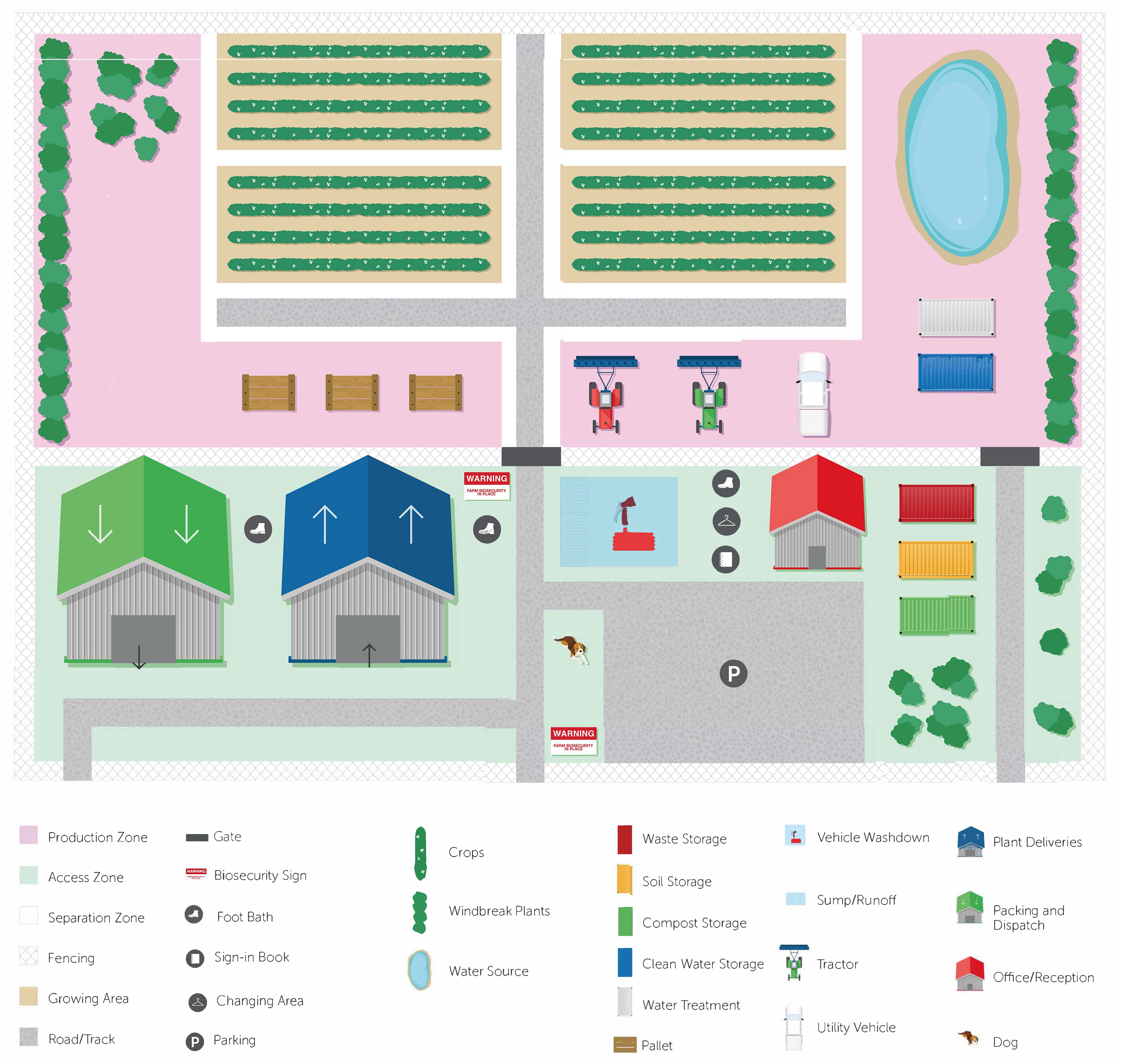
This map shows the relative positions of some facilities found on a farm in relation to the best place to put features like signs, parking or washdown areas. Green represents access zones, grey represents separation zones and pink represents the farming or production zones.
Every farm is different, so the general principles described here will need to be tailored to your needs. It is useful to start with a map of your property to consider risk areas, and the best places to locate biosecurity zones and checkpoints.
Movement should be restricted between zones where possible.
Where one zone meets the next – eg where a separation zone joins a production zone – there is a transition from one level of biosecurity to another.
Transition areas between should be marked by physical barriers such as fencing and signage. This could include signs at entrances to the property, parking areas near the house or site office, the location of deliveries and pick-ups in relation to storage facilities, vehicle wash-down areas, and existing roads or tracks for movement within the property. Think about what you can do to minimise the risk of introducing diseases, pests and weed seeds at each point.
The practices you choose may vary from paddock to paddock, depending on factors such as the size and location of your property, the facilities available, and the risks that need to be addressed.
Priority should be given to activities that minimise risks to your production areas.
Within your property, limit access to areas known to be free from pests and weeds to stop them from also becoming affected. In particular, apply rules for vehicle and equipment movements in production areas known to be infected to stop further spread.
Sheds where deliveries are received or where product washing and packing occurs might require a bit more thought, because part of both the separation and farming zone will extend into this area. This means that knowing where to draw the line between zones can be tricky.
Managing waste from wash down and decontamination is also a key consideration. Vehicle and equipment wash down areas should drain away from clean zones and growing areas. It’s best to have a hard surface for the wash down and a sump to collect water run-off.
Cost is a key factor in determining what measures you may put in place. It’s best to assess all risks before acting to ensure that you are targeting the areas of highest impact.
It’s also important to inform relevant service providers of any changes you may be making that will affect them, and to give them time to adjust to your new requirements.
A key element of zoning is that it creates a biosecurity system that is layered. By having a layered approach to biosecurity, it spreads the biosecurity risk across a range of measures, since no single biosecurity practice is 100 per cent effective.
Acknowledgment: Some of the information in this article is from a fact sheet produced by the Australian Banana Growers’ Council. The farm zone map was created with help from AUSVEG.